.png)


About
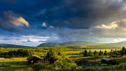
The Peer Gynt Trail leads through the mountain scenery on the western side of Gudbrandsdalen in the World of Peer Gynt. Ibsen’s Peer Gynt is based on a real person who once lived in the village of Sødorp by Vinstra, and has given name to this mountain area stretching south to Skeikampen, east to Kvitfjell, west to Espedalen and northwest to Skåbu. The World of Peer Gynt thus covers the eastern part of Huldreheimen. This is the beautiful and varied terrain through which the 70 km long Peer Gynt Trail runs (90 km via Kvitfjell). Along the way are several hotels and mountain lodges providing accommodation and meals. For organised trips, please contact Norske Bygdeopplevelser at Lillehammer.
During winter, the Peer Gynt cross-country ski trail runs through the same area.
Terrain
The mountains in the World of Peer Gynt offer ideal hiking terrain. Most of the route is at 900 – 1100 metres altitude, but the trail does reach 1500 m a.s.l. It runs through a varied terrain with a mix of bare mountains and birch forests. The route follows high-quality trails and farm roads, and has no highly demanding or exposed sections. However, hikers are advised to use sturdy footwear (walking boots or similar) as well as windproof and waterproof clothing.
Signs/way-marking
The trail is way-marked with PEER GYNT STIEN signs at the main crossroads. Small arrow-signs are also provided where the direction can be difficult to establish. In addition, stones with yellow paint are used for way-marking. At sections where the trail is easy to follow, the way-marking can be up to 100 m apart. Where the trail and direction are less obvious, way-marking is provided every 5-10 m. During the 2010 summer season, the trail will also be way-marked as a DNT route (Norwegian Mountain Touring Association) with beacons and red Ts.
Map
The recommended map is the World of Peer Gynt (no. 2563) on which the full Peer Gynt Trail is marked.
Starting points
Both ends of the Peer Gynt Trail can be used as starting point, and it is also possible to walk specific sections of the route. With Fagerhøy as starting point, the route is ideal for day-trips to Skeikampen, Gålå and Kvitfjell.
In the south, the trail starts at Skeikampen’s Thon Hotel Gausdal. From the hotel reception, follow the chairlift north until you reach a mountain farm road. Continue eastbound on this road until the trail again leads north. Then follow the Prestkamp trail on the eastern side of Skeikampen.
The eastern starting point is by GudbrandsGard Hotell at Kvitfjell, and from here the trail leads west towards Skardtjønn. It then continues across Svinslåa to Vendalen and joins the Peer Gynt Trail in the south between Fagerhøy and Lauvåsen Fjellstue. Another option is to walk from Kvitfjell towards Skeikampen.
In the north, the Peer Gynt Trail starts at Dalseter Høyfjellshotell/Ruten Fjellstue. This is also the starting point for the Peer Gynt Route. Follow the road for approx. 600 m eastbound, and then take the trail on the northern side and continue along towards Ruten (1516 m a.s.l.).
At Fagerhøy, the Peer Gynt Trail leads across the farm yard. Signs and yellow way-marking are available in both directions. This also applies to Lauvåsen Fjellstue.
At Wadahl, the trail leads south-west (direction Fagerhøi) from south of the hotel, and then past the stable where you will find a sign and yellow way-marking. Towards the north-west (direction Fefor), the trail runs from north of the hotel and follows the ski lift down to the mountain farm road. The trail continues north and joins the trail from Gålå Høgfjellshotell, and then leads west down the hill towards lake Gålåvatnet. From Gålå Høgfjellshotell, the way-marking starts 100 metres from the gate, and the trail is marked in both directions.
At Fefor, the trail leads straight past the reception, and is way-marked in both directions.
A short description of the Peer Gynt Trail from Skeikampen or Kvitfjell to Fagerhøy, and from Fagerhøi to Gålå:
Skei - Fagerhøi: approx. 20km, 7-8 hours.
The route follows the Prestkamp trail with a steady uphill climb on the eastern side of Skeikampen to Avlundskampen (approx. 1100 m a.s.l.). It then leads into the beautiful valley on the western side of Prestkampen and continues towards Skarbua. Along this stretch (see map) it is possible to choose alternative routes with hikes to the Skeikampen and Prestkampen peaks. From Skarbua, the trail turns west and runs through a beautiful, open high-mountain scenery to Fagerhøy.
Kvitfjell – Fagerhøy, approx. 18km, 7-8 hours.
From the mid-station at Kvitfjell, follow the trail east to Kvitfjellet mountain (1044 m a.s.l.). Then continue across Svinslåa mountain farm and follow the trail on the southern side of lake Vendalsvatnet. From the Vendalen mountain farms, a gentle climb will take you to the Peer Gynt Route. You can then follow the “lovers’ lane” to Fagerhøy or continue west until you reach the Peer Gynt Trail at Kantlia. From here, it is approx. 2 km to Fagerhøy. Varied terrain ranging from fir-tree forests to scattered woodland and bare mountains.
Fagerhøy - Lauvåsen – Gålå, approx. 16 km, 5 - 6 hours.
From Fagerhøy, the route follows the mountain farm road north-west towards Kantlia. As you approach Kantlia, the trail turns north across Kantliknappen, which, despite its modest height of only 1050 m a.s.l., offers spectacular panoramic views of areas such as Jotunheimen and Rondane. From Kantliknappen, the trail leads towards Lauvåsen Fjellstue where it runs straight through the yard. The route then follows the mountain farm road towards Bjørkåsen, before it continues north-west as a trail towards the Jetningen lake and on to the Wadahl and Gålå hotels. Gentle walk leading through a varied scenery with only minor differences in altitude.
Facilities
Duration
- 1 day
- several days
Grading
- medium
Nature and terrain
- forest
- mountain
Season
- Summer