To provide you with the best experience, cookies are used on this site. Find out more here.

Allow cookies

The Dørdal Round (17,7 km)

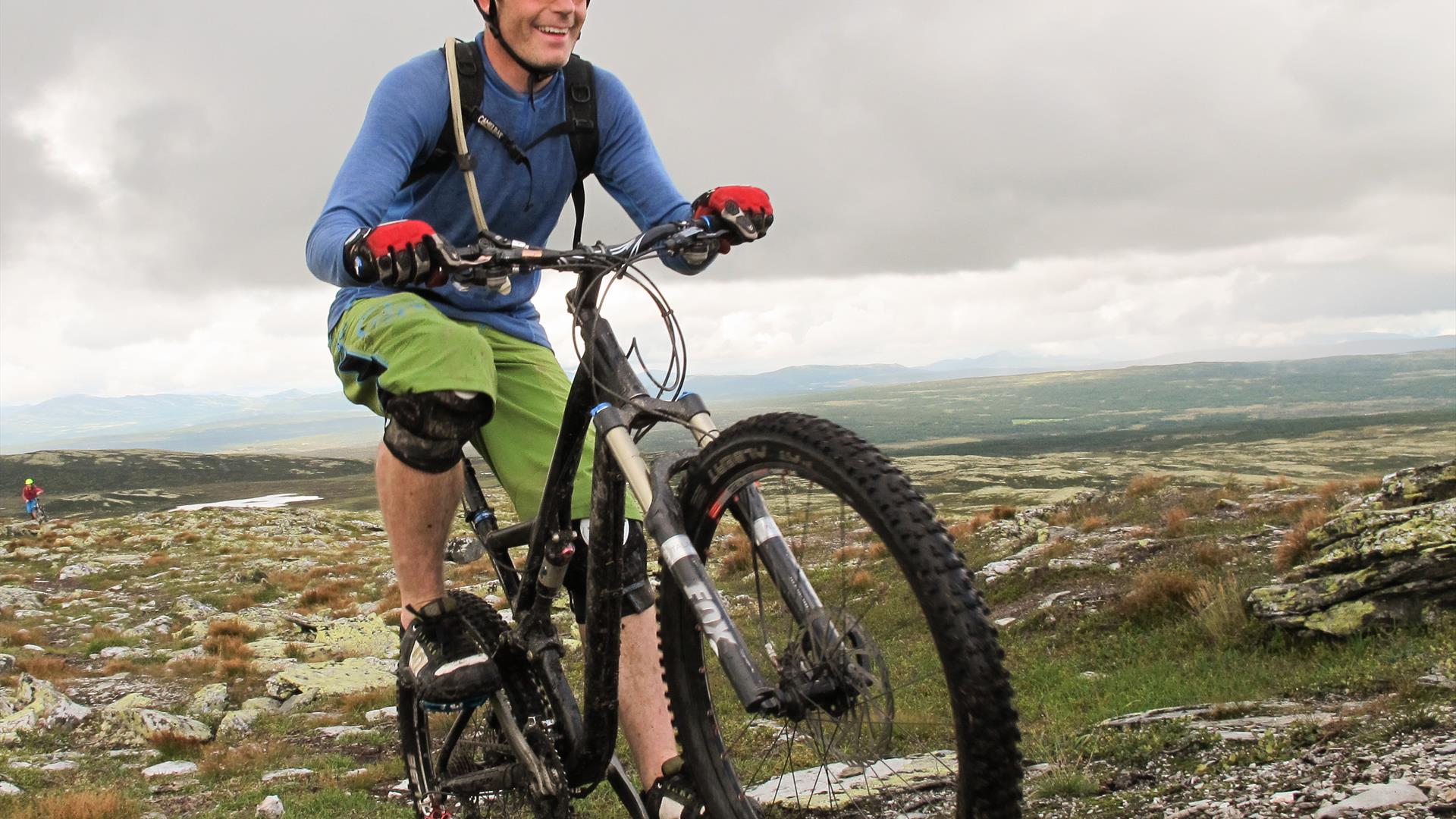
Man on a mountainbike active pedaling up a path in the Skeikampen area.
  • Man on a mountainbike active pedaling up a path in the Skeikampen area.
  • Bike leaned against railings with sheep in the background.

About

Spectacular two-hour round-trip along a fast flowing single-track route, with optional exhilarating descents. Excellent ride in either direction. A trip to the top of Dørdalsknappan is recommended for some adrenaline-fuelled downhill action.

By bike or pre-booked transport, follow the Peer Gynt Route for 8 km to the car park by the power line in Dørdalen. Ride up the trail running underneath the power line. Turn left at the top, and continue with lake Skjellbreia on your right. When you reach lake Storrøgna, turn right across the stream and follow the way-marked (T) Peer Gynt Trail on the southern side of the lake. As you reach the trail junction by the small cabin, turn left. Ride up and across the hill by the cabin, along the eastern side of lake Storrøgna and then to the foot of Gråkampen where the trail forks. Continue to the top, or turn left. 

After an excellent downhill segment, turn right across a small valley. Follow the trail around the Røgnmyrin marshes. As you start the climb after the marshes, keep right on the main trail. (Alternatively, ride along the ridge, and turn right as you reach the top.)

After another exciting descent, take a sharp left at the bottom and continue across the field. Turn right at the junction, and follow the Peer Gynt Trail back to the road. (Alternatively, turn left onto the Peer Gynt Route, and follow the signs for the vantage point. As you reach the car park, continue on the trail leading to the top of Dørdalsknappan. You will then have two exhilarating descents to choose from: along the ridge down to Svellesetra, or straight down towards Hovesetra).

Turn right as you reach the Peer Gynt Route. At the first crossroads, turn left and continue past Ånekresetra to Hovesetra. Then take the trail leading east, and follow the route used for Bukkerittet MTB race back across the hill and down to the car park.

(Source: Kippernes, Kristoffer. Stisykling i Norge, 2014).

Signposted "S3 Knutsholoa" (hiking map) from Skeikampen Velkomstsenter. 8.9 km or 10.9 km depending on route taken.

Facilities

Age limit

  • adult oriented

Distance

  • length in km - 17,7 km

Duration

  • 2 hours

General facilities

  • free parking

Grading

  • marked trails with colour grading
  • not marked
  • challenging

Nature and terrain

  • cultural landscape
  • forest area
  • gravel
  • major pathway
  • mountainous terrain
  • small path
  • total ascent - 362 m

Season

  • June - October

Sports activities

  • not illuminated trail

Get in touch

Tel: + 47 92 69 77 57

Senatorievegen 25
2652 Svingvoll

Add The Dørdal Round (17,7 km) to your Itinerary

What's Nearby

  1. Kvitfjell-Skardbua-Fagerhøi (46,7 km)

    At Skardbua, the mountain biking route starts with high-standard and challenging tracks…

    3.88 km away
  2. Trail to Prestkampen

    Prestkampen is the highest peak at Skeikampen, where you get a most wonderful view. This…

    4.22 km away
  3. The Peer Gynt Trail - 90 km

    The Peer Gynt Trail leads through the mountain scenery on the western side of…

    5.31 km away
  1. Dørdalsknappen og ”melkeveien” rundt

    Mountain-peak hike and round-trip - 9–10 km - 2-3 hours.
    Round-trip along the…

    5.35 km away
  2. Blå, Rundløype Fagerhøi (3,7 km)

    Ideal for beginners and young children enjoying their first skiing experience. The…

    5.37 km away
  3. Skei-Vesleseter (6,8 km)

    Ideal trip for skiers enjoying gentle terrain and shelter from the wind. A slightly hilly…

    5.85 km away
  4. Kyrakampen (10,9 km)

    A blue trail where skiers can enjoy a varied and hilly terrain up to Kyrakampen with its…

    5.85 km away
  5. Bjørga Rundt (6,9 km)

    Roundtrip from Austlid Fjellstue and around the Bjørga peak. Varied scenery comprising…

    5.85 km away
  6. The Skeikampen Round (13 km)

    Beautiful trail leading from the forest to the high mountain and back. Excellent trip in…

    6.75 km away
  7. Ski School | Skeikampen

    Whether you want private lessons or together as a group, the ski school can provide…

    6.78 km away
  8. Peer Gynt Road

    Enter the mythical country of Peer Gynt and the kingdom of the trolls as you follow this…

    6.80 km away
  9. The Rausjø round (24,5 km)

    Nice familyfriendly route in varied terrain and scenic surrounding.

    Skeikampen – Austlid…

    6.81 km away
  10. Trail around Skeikampen

    This great trail around Skeikampen is around 8 km long, over gently sloping terrain, and…

    6.83 km away
  11. Skeikampen Alpine centre

    Skeikampen Alpine Centre offers 11 lifts and 21 slopes totaling 21 kilometers, with an…

    6.86 km away
  12. Trail to Kyrakampen and Knutsholoa

    A slightly longer trek to the summit of Kyrakampen that offers incredible views of…

    6.86 km away
  13. Biketrail - Skeikampen-Torsdalen-Gammeldalen (5 km)

    A beautiful bike ride for the whole family.

    6.86 km away
Previous Next

Plan your trip

  • Things to Do
    Search

  • Accommodation
    Search

  • What's On
    Search

  • Food & Drink
    Search

Search Things to Do

Eco-certified providers
Type:
Location:
Location
Name / Keyword:

Search Accommodation

Eco-certified providers
Type:
Location:
Location
Name / Keyword:

Search What's On

Eco-certified providers
Type:
Location:
Location
Name / Keyword:
Dates

Search Eating & Drinking

Eco-certified providers
Type:
Location:
Location
Name / Keyword:

Plan your trip

Search Things to Do

Eco-certified providers
Type:
Location:
Location
Name / Keyword:

Search Accommodation

Eco-certified providers
Type:
Location:
Location
Name / Keyword:

Search What's On

Eco-certified providers
Type:
Location:
Location
Name / Keyword:
Dates

Search Eating & Drinking

Eco-certified providers
Type:
Location:
Location
Name / Keyword: